Environmental Permits
 Protection of Water Resources
Much of Florida’s distinctive character lies in the beauty of its natural features, especially its coastlines. This natural beauty has always been one of Florida’s major attractions for both tourists and residents. Ironically, the very features that draw people to Florida are potentially endangered by the increased population pressures. To protect these distinctive natural features for the enjoyment of future generations, the Florida Legislature has enacted laws to regulate activities which may potentially pollute or destroy environmentally sensitive lands and waters. Laws and regulations have also been enacted to protect wetlands, seagrasses, mangroves, and endangered species such as manatees and sea turtles.
Generally, any activity conducted in, on, or over the surface waters of the State of Florida will require a permit from the Florida Department of Environmental Protection and/or the State Water Management District. Such activities generally are also regulated by the counties and municipalities within the State.
Unless expressly exempted from permitting requirements, it is unlawful to conduct an activity, in, on or over surface waters, such as the construction of a dock, without first obtaining the required permit from the appropriate governmental agency. Any activity conducted without a required permit is considered a “public nuisance” and may be required to be removed.
State and local governmental regulations provide specific criteria intended to protect waters and other natural resources which must be met before a permit will be issued. Such regulations may affect the location, size, configuration, and manner of construction of such activities as single-family docks, single-family dredge and fill, and shoreline stabilization (e.g., seawalls, bulkheads, and rip-rap).
In particular, for example, in order to obtain an Environmental Resource Permit from the State of Florida, an applicant will be required to demonstrate that the proposed activity will (1) not adversely affect public health, safety and welfare of the property of others; (2) not adversely affect fish and wildlife; (3) not impair navigation or surface water flows; (4) not adversely affect nearby fishing or recreational uses; and (5) not increase the potential for flooding or discharge of pollutants.
Special Waters
Certain water bodies are provided with special heightened protection as a result of outstanding natural attributes. In order to conduct activities within these waters, classified as “Outstanding Florida Waters”, additional standards must be satisfied. In particular, it must be demonstrated that the proposed activity will not result in a lowering of existing water quality, and that the proposed activity is “clearly in the public interest”.
Frequently, in order to demonstrate that a proposed activity is Aclearly in the public interest@, a permit applicant will place the remaining wetlands upon the applicant’s property within a “Conservation Easement”, intended to preserve said wetlands in an undisturbed state in perpetuity.
Certain Outstanding Florida Waters are of such exceptional beauty and ecological significance that the Florida Legislature has designated such waters as “Aquatic Preserves”. The management objectives for the Aquatic Preserves are to maintain and improve existing resources such as seagrasses, mangroves, aquatic plants, birds and fish. In practice, construction activities within Aquatic Preserves are regulated even more severely than those activities within Outstanding Florida Waters. Aquatic preserve regulations pertaining to the construction of a single-family boat dock, for example, require water depths which would provide at least one foot clearance between the top of seagrasses in the vicinity of the proposed dock, and the lowest portion of the boat to be moored said dock.
Most of the bay waters in Sarasota and Manatee Counties are classified as “Outstanding Florida Waters”, including the intracoastal waterway in Venice, Anna Maria Sound, Passage Key Inlet, Perico Bay, Palma Sola Bay, Longboat Pass, Sarasota Bay, New Pass, Big Sarasota Pass, Roberts Bay, Little Sarasota Bay, Dryman Bay, Blackburn Bay, Lyons Bay, Venice Inlet, and Dona Bay. Typically, neither natural nor artificial tributaries to such water bodies have been designated as “Outstanding Florida Waters”.
The waters of Lemon Bay in Sarasota and Charlotte Counties, have been designated as an “Aquatic Preserve”. Such waters include Placida Harbor, Gasparilla Pass, Kettle Harbor, Bocilla Lagoon, Bocilla Pass, Knight Pass, Stump Pass, Lemon Bay, and certain portions of Buck Creek, Oyster Creek, Ainger Creek, and Godfrey Creek.
Dredge and Fill Permitting
The Florida Department of Environmental Protection (“DEP”) regulates dredging and filling in wetlands and other surface waters in order to protect the environment. Most residential dredging and filling by waterfront property owners will require a permit from the DEP. If the proposed activities are located on State-owned submerged lands, written authorization to use these lands may also be required from the DEP. Both the permit and authorization, if required, must be obtained prior to construction.
What is Filling?
The term “filling” includes the placement or depositing of any material that is placed in wetlands or other surface waters. Dirt, sand, gravel, rocks, shell, pilings, and concrete are all considered fill if placed in wetlands.
What is Dredging?
The term “dredging” refers to any type of excavation conducted in wetlands or other surface waters. Dredging includes digging, pulling up vegetation by the roots, leaving vehicular ruts, or any other activity that disturbs the soil.
What types of projects involve dredging and filling?
The following types of projects when proposed by single-family waterfront property owners and located in wetlands or surface waters, generally require permits from the DEP:
- Filling for a house pad, septic tank drainfield, driveway, lawn, etc.
- Removing trees or other vegetation by pulling out the root ball
- Installing a fence
- Placing sand along the edge of a waterbody for a beach
- Construction of a boat dock
- Placing materials along a shoreline to create a seawall or rip-rap
- Dredging in a waterway to provide new boating access
- Dredging in a wetland to create a pond
- Dredging a ditch to drain property
- A number of dredge and fill activities are exempt from DEP permitting including:
- Installation and repair of mooring pilings at private docks
- Installation of private docks of 1000 square feet or less of surface area over waters, 500 square feet or less when conducted in an Outstanding Florida Water
- Maintenance dredging of existing man-made canals and channels
- Construction of seawalls or rip-rap in man-made waterways
- Construction of docks in man-made waterways
- Replacement or repair of existing docks
What kind of permit is needed for dredging and filling?
Any activity which is not exempt from permitting activities will require an Environmental Resource Permit from the DEP. Depending upon the magnitude of the proposed activity, a Standard Permit, General Permit, or a Noticed General Permit may be required. The provisions of Chapter 62, Florida Administrative Code must be consulted to determine what type of permit will be required.
What other agencies regulate dredging and filling?
Dredging and filling is also regulated by the U.S. Army Corps of Engineers, the Florida Water Management Districts, Counties and Municipalities. Each jurisdiction should be consulted to determine the specific requirements concerning a proposed project.
Source: “Single-Family Dredge and Fill and the Department of Environmental Protection”. FDEP
Single-Family Dock Permitting
The Florida Department of Environmental Protection (“DEP”) regulates the construction of docks in order to protect habitat and water quality associated with the State’s surface waterbodies. Such construction is also regulated in an effort to manage the use of state-owned submerged lands. Therefore, prior to construction, generally a permit will need to be obtained from the DEP for the construction of a dock and the use of sovereign lands. Some docks may be exempt from permitting requirements where, due to their size and location, the docks can be expected to have minimal environmental impacts. A Consent of Use may be required to construct an exempt dock on State Lands.
Permits for the construction of single family docks may also be required by the U.S. Army Corps of Engineers and the county or municipalities. Such additional jurisdictions may impose more stringent requirements than the State DEP, particularly when impacts to manatees and/or seagrasses are involved. If a permit is requested in an area frequented by manatees and where seagrass is present, U.S. Army Corps of Engineers permits may be denied in the absence of a local manatee protection plan.
Local regulations may impose restrictions on vessel length and vessel draft, particularly in artificially created waterways where such limitations are necessary to maintain safe navigation.
What docks do not need a permit or other authorization from the DEP?
 A private dock in an artificially created waterway where:
- the construction will not violate water quality standards
- the dock will not impede navigation
- the dock will not affect flood control
- Repairing or replacing existing docks or mooring pilings that:
- are not part of an aquatic preserve or manatee sanctuary
- are still functional or only recently damaged
- are in the same location, configuration, and dimensions as the existing structure
- are built without fill other than the pilings
- A single-family dock that meets the following criteria:
- not part of an aquatic preserve or manatee sanctuary
- 500 square feet or less if located in “Outstanding Florida Waters”
- 1,000 square feet or less if not located in “Outstanding Florida Waters”
- structures built on the dock such as gazebos and boat shelters and are not enclosed with walls and doors, are not used as living quarters or for the storage of materials other than recreational supplies
- used only for recreational, noncommercial activities
- there is no dredging or filling except for that necessary to install pilings
- the dock and pilings do not impede the flow of water or navigation
- only one dock per lot and no more than one dock per single family home
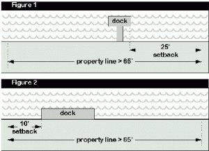
- if the length of the shoreline is 65 feet or more:
- docks with access walkways must be set back at least 25 feet from the property lines (see figure 1)
- docks without access walkways (marginal docks) must be set back at least 10 feet from the property lines (see figure 2)
- if the shoreline length is less than 65 feet, the dock should be centered between property lines
What is required to obtain a Consent of Use to build a dock on State Lands?
- the dock must extend only far enough to reach a maximum water depth of 4 feet below mean low water, 20% of the width of the waterbody, or 500 feet, whichever is less
- if there is a bulkhead along the shoreline and the water depth at that point is already 4 feet below mean low water, the dock must not extend more than 25 feet beyond the bulkhead
- the access walkway of the dock must not be more than 4 feet wide
- the terminal platform must be no larger than 160 square feet
- if the dock is over seagrasses, the boards used to construct the surface of the dock must be no more than 8 inches wide and are spaced at least 1/2 inch apart
- any part of the dock located over seagrasses must be elevated 5 feet above the mean high water line
- if the dock is located within an Aquatic Preserve, there must be at least 1 foot clearance (at mean low water) between the top of seagrasses and the bottom of the deepest part of the proposed boat or motor in the area to be used for boat mooring, turning, or access to deep water
Source: “Single-Family Dock Construction and the Florida Department of Environmental Protection”. FDEP
Shoreline Stabilization Permitting
 The Department of Environmental Protection (“DEP”) regulates the construction of seawalls, rip-rap, and other shoreline stabilization structures in order to protect the quality of Florida’s surface waters, to protect the beach and dune system, and to protect upland property along the shoreline. Certain types of shoreline stabilization structures, because of their size, location, or proximity to other stabilization structures, can be expected to have minimal environmental impacts, and as a result, are exempt from State permitting requirements. A Consent of Use may be required to construct exempt structures on State Lands.
What shoreline stabilization structures are exempt from DEP permitting?
- A private seawall or rip-rap in an artificially created waterway, where the proposed work:
- does not violate state water quality standards
- does not impede navigation
- does not affect flood control
- includes only that backfilling needed to level the land behind the seawall
- does not involve a vertical seawall unless the proposed wall is within an existing man-made canal where legal vertical seawalls already exist along the shoreline of the canal
- Restoration of an existing seawall or rip-rap that meets all the following criteria:
- the existing wall is still functional (no breaks which allow water to flow through the seawall) or only recently damaged
- the new wall is constructed at its previous location, upland of its previous location, or within one foot waterward of its previous location
- the new wall involves no filling except for that used in the actual restoration of the seawall or rip-rap
- the existing wall is not located in an Aquatic Preserve or manatee sanctuary
- the new wall is not located waterward of the coastal construction control line
- A private seawall or rip-rap which is not located on State-owned submerged lands and meets all of the following conditions:
- the new wall is built between existing, legal seawalls or rip-rap and connects them at both ends in a continuous and uniform construction line which “closes the gap”
- the new wall is not more than 150 feet in length
- the new wall is not a vertical seawall
- the new wall is not located seaward of the coastal construction control line
- the work or materials do not cause violations of state water quality standards
- the new wall will not impede navigation
- the new wall will not affect flood control
What must be shown to construct a shoreline stabilization structure on State Lands?
- There must be an adequate demonstration of significant erosion at the subject site
- There are not viable alternatives to protect the uplands
- The project design includes rip-rap or non-structural shoreline stabilization (such as planting vegetation) if practicable
What are the alternatives to vertical seawalls?
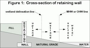
Retaining Walls are identical to seawalls, but all portions of the wall are in the uplands. A retaining wall may be built without a permit from the DEP if all activities (dredging, filling, slope grading, or equipment access) are confined to the uplands (see Figure 1) and the wall is located landward of the coastal construction control line.
Vegetation is a natural and inexpensive way to stabilize a shoreline. It can be used alone or in combination with other methods. Vegetation may be planted directly into the soil or with a fiber mat added for stability. Planting of native vegetation may not require a permit or Consent of Use.
Rip-Rap, which consists of loose boulders, rocks, or clean concrete rubble, can be placed along the water’s edge to stabilize the shoreline and disperse the energy of the waves.
Source: “Shoreline Stabilization and the Department of Environmental Protection”. FDEP
Important Terms
- Conservation Easement
- The projection of long-term shoreline recession occurring over a period of 30 years based on shoreline change information obtained from historical measurements.
- Mean High Water Line
- The boundary line along navigable waters between submerged lands including the foreshore, owned by the State in its sovereign capacity, and uplands subject to private ownership.
- Riparian Rights
- Those rights incident to the ownership of lands bordering upon navigable waters. They are rights of ingress, egress, boating, bathing, fishing, and the right to an unobstructed view of the channel. Riparian rights also include the right to accretions to riparian lands. Subject to reasonable governmental restrictions, riparian rights also include the right to build a dock to access navigable waters.
It is a common misconception that riparian rights apply to all waters. Under Florida Law, however, only lands bordering waters which were navigable at the time of Florida’s statehood on March 3,1845 are benefitted by riparian rights. Such rights do not apply to artificially erected waterbodies. While generally, riparian rights lines typically are drawn from the extension of the upland property lines, for shorelines that do not run at right angles to the property lines, the riparian rights lines are apportioned between the owners along the shoreline. - State-Owned, Sovereignty Submerged Lands
- Lands beneath navigable waters below the mean high water line, title to which was vested in the State of Florida upon its statehood in 1845, and which have not subsequently been conveyed to private ownership.

